
Make a donation
Gear up for your next adventure:
As an Amazon Associate, this site earns from qualifying purchases at no extra cost to you.
Bildstein topographic map
Click on the map to display elevation.
Make a donation
Gear up for your next adventure:
As an Amazon Associate, this site earns from qualifying purchases at no extra cost to you.
Bildstein
Bildstein liegt im westlichsten Bundesland Österreichs, Vorarlberg, im Bezirk Bregenz südlich des Bodensees auf 659 Metern Höhe (Ortskern). 45,1 % der Fläche sind bewaldet. Es existieren keine weiteren Katastralgemeinden in Bildstein. Die höchste Erhebung ist der Schneiderkopf mit 971 m ü. A. an der Grenze zu Buch.
Make a donation
Gear up for your next adventure:
As an Amazon Associate, this site earns from qualifying purchases at no extra cost to you.
About this map
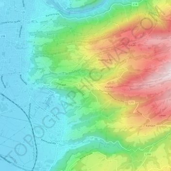
Name: Bildstein topographic map, elevation, terrain.
Average elevation: 585 m
Minimum elevation: 409 m
Maximum elevation: 926 m
Make a donation
Gear up for your next adventure:
As an Amazon Associate, this site earns from qualifying purchases at no extra cost to you.