
Parque Nacional Tirgua topographic map
Interactive map
Click on the map to display elevation.
About this map
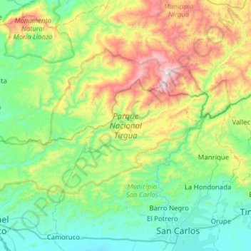
Name: Parque Nacional Tirgua topographic map, elevation, terrain.
Location: Parque Nacional Tirgua, Cojedes, Central, Venezuela (9.71962 -68.98919 10.02637 -68.48184)
Average elevation: 535 m
Minimum elevation: 112 m
Maximum elevation: 1,747 m