
Thank you for supporting this site ❤️
Make a donation
Make a donation
Gear up for your next adventure:
As an Amazon Associate, this site earns from qualifying purchases at no extra cost to you.
Tugatog topographic map
Click on the map to display elevation.
Thank you for supporting this site ❤️
Make a donation
Make a donation
Gear up for your next adventure:
As an Amazon Associate, this site earns from qualifying purchases at no extra cost to you.
About this map
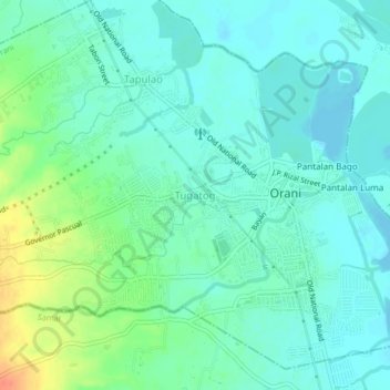
Name: Tugatog topographic map, elevation, terrain.
Location: Tugatog, Orani, Bataan, Central Luzon, 2122, Philippines (14.78098 120.50658 14.82098 120.54658)
Average elevation: 13 m
Minimum elevation: 0 m
Maximum elevation: 47 m
Thank you for supporting this site ❤️
Make a donation
Make a donation
Gear up for your next adventure:
As an Amazon Associate, this site earns from qualifying purchases at no extra cost to you.