
Make a donation
Gear up for your next adventure:
As an Amazon Associate, this site earns from qualifying purchases at no extra cost to you.
Honeygo topographic map
Click on the map to display elevation.
Make a donation
Gear up for your next adventure:
As an Amazon Associate, this site earns from qualifying purchases at no extra cost to you.
About this map
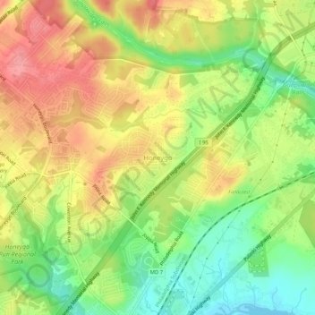
Name: Honeygo topographic map, elevation, terrain.
Location: Honeygo, Baltimore County, Maryland, 21162, United States (39.38470 -76.44696 39.42470 -76.40696)
Average elevation: 47 m
Minimum elevation: -1 m
Maximum elevation: 91 m
Make a donation
Gear up for your next adventure:
As an Amazon Associate, this site earns from qualifying purchases at no extra cost to you.
Other topographic maps
Click on a map to view its topography, its elevation and its terrain.
Bowleys Quarters
United States > Maryland > Baltimore County > Bowleys Quarters
Average elevation: 2 m
Make a donation
Gear up for your next adventure:
As an Amazon Associate, this site earns from qualifying purchases at no extra cost to you.
Soldiers Delight Natural Environment Area
United States > Maryland > Baltimore County > Owings Mills
Average elevation: 187 m
Make a donation
Gear up for your next adventure:
As an Amazon Associate, this site earns from qualifying purchases at no extra cost to you.
Make a donation
Gear up for your next adventure:
As an Amazon Associate, this site earns from qualifying purchases at no extra cost to you.