
Soldeu topographic map
Interactive map
Click on the map to display elevation.
About this map
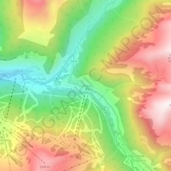
Name: Soldeu topographic map, elevation, terrain.
Location: Soldeu, Canillo, AD100, Andorra (42.55689 1.64827 42.59689 1.68827)
Average elevation: 2,091 m
Minimum elevation: 1,651 m
Maximum elevation: 2,571 m
The village is at an elevation of 1,710 metres (5,610 ft) above sea level and the top of the ski area is at 2,580 m (8,465 ft). The gondola from the village rises to 2,250 m (7,380 ft), where the ski and board schools as well as restaurants are located. From there, it is possible to ski to the top of the El Tarter gondola or the village of El Tarter itself via the blue-rated 'gall de bosc' run.
Other topographic maps
Click on a map to view its topography, its elevation and its terrain.