
Make a donation
Gear up for your next adventure:
As an Amazon Associate, this site earns from qualifying purchases at no extra cost to you.
Vaud topographic map
Click on the map to display elevation.
Make a donation
Gear up for your next adventure:
As an Amazon Associate, this site earns from qualifying purchases at no extra cost to you.
About this map
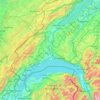
Name: Vaud topographic map, elevation, terrain.
Location: Vaud, Switzerland (46.18707 6.06386 46.98690 7.24919)
Average elevation: 840 m
Minimum elevation: 361 m
Maximum elevation: 2,938 m
Make a donation
Gear up for your next adventure:
As an Amazon Associate, this site earns from qualifying purchases at no extra cost to you.
Other topographic maps
Click on a map to view its topography, its elevation and its terrain.
Make a donation
Gear up for your next adventure:
As an Amazon Associate, this site earns from qualifying purchases at no extra cost to you.
Make a donation
Gear up for your next adventure:
As an Amazon Associate, this site earns from qualifying purchases at no extra cost to you.
Windegghoren
Switzerland > Bern > Interlaken-Oberhasli administrative district > Innertkirchen
Average elevation: 2,277 m
Vilbringen
Switzerland > Bern > Emmental administrative district > Kirchberg (BE)
Average elevation: 529 m
Make a donation
Gear up for your next adventure:
As an Amazon Associate, this site earns from qualifying purchases at no extra cost to you.
Brienz
Switzerland > Bern > Interlaken-Oberhasli administrative district > Brienz (BE)
Average elevation: 810 m
Hinter Spitzenegg
Switzerland > Bern > Emmental administrative district > Langnau im Emmental > Obeningohl
Average elevation: 948 m
Make a donation
Gear up for your next adventure:
As an Amazon Associate, this site earns from qualifying purchases at no extra cost to you.
Jungfrau
Switzerland > Bern > Interlaken-Oberhasli administrative district > Lauterbrunnen
The difference of altitude between the deep valley of Lauterbrunnen (800 m or 2,600 ft) and the summit is particularly visible from the area of Mürren. From the valley floor, west of the massif, the altitude gain is more than 3 km (1.9 mi) for a horizontal distance of 4 km (2.5 mi).
Average elevation: 3,401 m
Make a donation
Gear up for your next adventure:
As an Amazon Associate, this site earns from qualifying purchases at no extra cost to you.
Monte Rosa
Switzerland > Wallis > Visp > Zermatt
The peak is distinguished by the name Dufourspitze (in German, lit. Dufour Peak; French: Pointe Dufour, Italian: Punta Dufour). This replaced the former name Höchste Spitze (English: Highest Peak) that was indicated on the Swiss maps before the Federal Council, on January 28, 1863, decided to rename the…
Average elevation: 4,033 m
Lausanne
Switzerland > Vaud > District de Lausanne > Lausanne
The most important geographical feature of the area surrounding Lausanne is Lake Geneva (Lac Léman in French). Lausanne is built on the southern slope of the Swiss plateau, with a difference in elevation of about 500 metres (1,640 ft) between the lakeshore at Ouchy and its northern edge bordering Le…
Average elevation: 577 m
Make a donation
Gear up for your next adventure:
As an Amazon Associate, this site earns from qualifying purchases at no extra cost to you.
Hasliberg Wasserwendi
Switzerland > Bern > Interlaken-Oberhasli administrative district
Average elevation: 1,247 m
Ruins
Switzerland > Ticino > Distretto di Lugano > Tresa > Monteggio > Cassinone
Average elevation: 476 m
Make a donation
Gear up for your next adventure:
As an Amazon Associate, this site earns from qualifying purchases at no extra cost to you.
Oeschinen Lake
Switzerland > Bern > Frutigen-Niedersimmental administrative district > Kandersteg
Oeschinen Lake (German: Oeschinensee) is a lake in the Bernese Oberland, Switzerland, 4 kilometres (2.5 mi) east of Kandersteg in the Oeschinen valley. At an elevation of 1,578 metres (5,177 ft), it has a surface area of 1.1147 square kilometres (0.4304 sq mi). Its maximum depth is 56 metres (184 ft).
Average elevation: 1,918 m
Make a donation
Gear up for your next adventure:
As an Amazon Associate, this site earns from qualifying purchases at no extra cost to you.
Sankt Stephan
Switzerland > Bern > Obersimmental-Saanen administrative district > St. Stephan
Average elevation: 1,310 m
Make a donation
Gear up for your next adventure:
As an Amazon Associate, this site earns from qualifying purchases at no extra cost to you.
Make a donation
Gear up for your next adventure:
As an Amazon Associate, this site earns from qualifying purchases at no extra cost to you.
Furi
Switzerland > Valais/Wallis > Visp > Zermatt
Furi is an alpine hamlet in the Pennine Alps, located three kilometers south of Zermatt, Switzerland at an altitude of 1,687m. It is located on a relatively flat area of land between the Gornera and Zmuttbach rivers.
Average elevation: 2,206 m
Make a donation
Gear up for your next adventure:
As an Amazon Associate, this site earns from qualifying purchases at no extra cost to you.
Valle Verzasca
Switzerland > Ticino > Distretto di Locarno > Verzasca
Located between the Leventina and the Valle Maggia valleys, Valle Verzasca extends over a length of 25 kilometres (16 mi) in north–south direction and is situated in the north of the Lago Maggiore. The valley floor is at about 500 metres (1,640 ft) to 900 metres (2,953 ft) above sea level. The surrounding…
Average elevation: 1,398 m
Make a donation
Gear up for your next adventure:
As an Amazon Associate, this site earns from qualifying purchases at no extra cost to you.
Sigriswiler Rothorn
Switzerland > Bern > Thun administrative district > Sigriswil
Average elevation: 1,552 m
Make a donation
Gear up for your next adventure:
As an Amazon Associate, this site earns from qualifying purchases at no extra cost to you.
Gimmelwald
Switzerland > Bern > Interlaken-Oberhasli administrative district
Average elevation: 1,564 m
Make a donation
Gear up for your next adventure:
As an Amazon Associate, this site earns from qualifying purchases at no extra cost to you.
Jungfrau
Switzerland > Bern > Interlaken-Oberhasli administrative district > Lauterbrunnen
The difference of altitude between the deep valley of Lauterbrunnen (800 m or 2,600 ft) and the summit is particularly visible from the area of Mürren. From the valley floor, west of the massif, the altitude gain is more than 3 km (1.9 mi) for a horizontal distance of 4 km (2.5 mi).
Average elevation: 3,401 m
Eiger
Switzerland > Bern > Interlaken-Oberhasli administrative district > Grindelwald
Average elevation: 2,944 m
Make a donation
Gear up for your next adventure:
As an Amazon Associate, this site earns from qualifying purchases at no extra cost to you.
Männlichen
Switzerland > Bern > Interlaken-Oberhasli administrative district > Grindelwald
Average elevation: 1,709 m
Blüemlisalp
Switzerland > Appenzell Innerrhoden > Schwende-Rüte > Wasserauen
Average elevation: 1,208 m
Make a donation
Gear up for your next adventure:
As an Amazon Associate, this site earns from qualifying purchases at no extra cost to you.
Faulensee
Switzerland > Bern > Frutigen-Niedersimmental administrative district > Spiez
Average elevation: 638 m
Wildhaus
Switzerland > St. Gallen > Wahlkreis Toggenburg > Wildhaus-Alt St. Johann
Average elevation: 1,244 m
Make a donation
Gear up for your next adventure:
As an Amazon Associate, this site earns from qualifying purchases at no extra cost to you.
Make a donation
Gear up for your next adventure:
As an Amazon Associate, this site earns from qualifying purchases at no extra cost to you.
Gimmelwald
Switzerland > Bern > Interlaken-Oberhasli administrative district
Average elevation: 1,564 m
Make a donation
Gear up for your next adventure:
As an Amazon Associate, this site earns from qualifying purchases at no extra cost to you.
Schilthorn
Switzerland > Bern > Interlaken-Oberhasli administrative district > Lauterbrunnen
Average elevation: 2,455 m
Kiental
Switzerland > Bern > Frutigen-Niedersimmental administrative district > Reichenbach im Kandertal
Since 1910, the nearby mountain of Niesen (altitude 2,362 m [7,749 ft]) can be ascended at gradients of up to 68% via the Niesenbahn, which with a length of 3,499 m (11,480 ft) is the longest funicular railway in Europe.
Average elevation: 1,509 m
Make a donation
Gear up for your next adventure:
As an Amazon Associate, this site earns from qualifying purchases at no extra cost to you.
Chlinismad
Switzerland > Bern > Thun administrative district > Forst-Längenbühl > Längenbühl
Average elevation: 638 m
Make a donation
Gear up for your next adventure:
As an Amazon Associate, this site earns from qualifying purchases at no extra cost to you.
Make a donation
Gear up for your next adventure:
As an Amazon Associate, this site earns from qualifying purchases at no extra cost to you.
Kiental
Switzerland > Bern > Frutigen-Niedersimmental administrative district > Reichenbach im Kandertal
Average elevation: 1,363 m
Reichenbach im Kandertal
Switzerland > Bern > Frutigen-Niedersimmental administrative district
Average elevation: 1,906 m
Make a donation
Gear up for your next adventure:
As an Amazon Associate, this site earns from qualifying purchases at no extra cost to you.
Make a donation
Gear up for your next adventure:
As an Amazon Associate, this site earns from qualifying purchases at no extra cost to you.
Dents du Midi
Switzerland > Wallis > Monthey > Val-d'Illiez
The Dents du Midi are situated on the border between the communes of Val-d'Illiez and Evionnaz. The north face rises above the Val d'Illiez while the south face overlooks the Lac de Salanfe, an artificial reservoir. The ridge of the chain is situated at an altitude varying between 2,997 and 3,258 meters (9,833…
Average elevation: 2,440 m
Eau-Rouge
Switzerland > Wallis > Entremont > Chamoille (Sembrancher) > Les Champmanins
Average elevation: 1,034 m
Make a donation
Gear up for your next adventure:
As an Amazon Associate, this site earns from qualifying purchases at no extra cost to you.