
Thank you for supporting this site ❤️
Make a donation
Make a donation
Gear up for your next adventure:
As an Amazon Associate, this site earns from qualifying purchases at no extra cost to you.
Pancrudo topographic map
Click on the map to display elevation.
Thank you for supporting this site ❤️
Make a donation
Make a donation
Gear up for your next adventure:
As an Amazon Associate, this site earns from qualifying purchases at no extra cost to you.
Pancrudo
It is located at high altitude among the Sistema Ibérico mountains.
Thank you for supporting this site ❤️
Make a donation
Make a donation
Gear up for your next adventure:
As an Amazon Associate, this site earns from qualifying purchases at no extra cost to you.
About this map
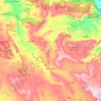
Name: Pancrudo topographic map, elevation, terrain.
Location: Pancrudo, Comunidad de Teruel, Teruel, Aragon, 44720, Spain (40.71859 -1.08973 40.85503 -0.94016)
Average elevation: 1,251 m
Minimum elevation: 990 m
Maximum elevation: 1,429 m
Thank you for supporting this site ❤️
Make a donation
Make a donation
Gear up for your next adventure:
As an Amazon Associate, this site earns from qualifying purchases at no extra cost to you.