
Darlington County topographic map
Interactive map
Click on the map to display elevation.
About this map
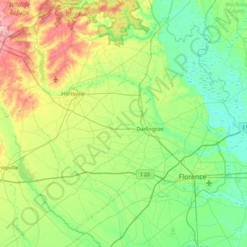
Name: Darlington County topographic map, elevation, terrain.
Location: Darlington County, South Carolina, United States (34.08519 -80.28876 34.53522 -79.65673)
Average elevation: 53 m
Minimum elevation: 10 m
Maximum elevation: 171 m
Other topographic maps
Click on a map to view its topography, its elevation and its terrain.
Palmetto Dunes
United States > South Carolina > Beaufort County > Hilton Head Island
Average elevation: 3 m