
Châtillon-sur-Indre topographic map
Interactive map
Click on the map to display elevation.
About this map
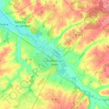
Name: Châtillon-sur-Indre topographic map, elevation, terrain.
Average elevation: 115 m
Minimum elevation: 79 m
Maximum elevation: 154 m
Other topographic maps
Click on a map to view its topography, its elevation and its terrain.
Les Ravineaux
France > Centre-Val de Loire > Indre > Villentrois-Faverolles-en-Berry
Les Ravineaux, Faverolles-en-Berry, Villentrois-Faverolles-en-Berry, Châteauroux, Indre, Centre-Val de Loire, Metropolitan France, 36360, France
Average elevation: 131 m