
Tirana Municipality topographic map
Interactive map
Click on the map to display elevation.
Tirana Municipality
Tirana extends at the Plain of Tirana in the centre of Albania between the mount of Dajti in the east, the hills of Kërrabe, Sauk and Vaqarr in the south, and a valley to the north overlooking the Adriatic Sea. The average altitude is about 110 meters (360 ft) above sea level, with a maximum of 1,828 metres (5,997 feet) at Maja Mincekut of Mali me Gropa in Shenmeri.
About this map
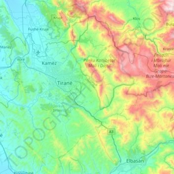
Name: Tirana Municipality topographic map, elevation, terrain.
Location: Tirana Municipality, Tirana County, Central Albania, Albania (41.11609 19.59377 41.51540 20.23995)
Average elevation: 380 m
Minimum elevation: -3 m
Maximum elevation: 1,809 m
Other topographic maps
Click on a map to view its topography, its elevation and its terrain.