
Make a donation
Gear up for your next adventure:
As an Amazon Associate, this site earns from qualifying purchases at no extra cost to you.
Aulnay topographic map
Click on the map to display elevation.
Make a donation
Gear up for your next adventure:
As an Amazon Associate, this site earns from qualifying purchases at no extra cost to you.
About this map
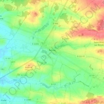
Name: Aulnay topographic map, elevation, terrain.
Average elevation: 66 m
Minimum elevation: 35 m
Maximum elevation: 111 m
Make a donation
Gear up for your next adventure:
As an Amazon Associate, this site earns from qualifying purchases at no extra cost to you.
Other topographic maps
Click on a map to view its topography, its elevation and its terrain.
Make a donation
Gear up for your next adventure:
As an Amazon Associate, this site earns from qualifying purchases at no extra cost to you.
Grand-Village
France > Nouvelle-Aquitaine > Charente-Maritime > Le Grand-Village-Plage
Average elevation: 4 m
Make a donation
Gear up for your next adventure:
As an Amazon Associate, this site earns from qualifying purchases at no extra cost to you.
La Chainade
France > Nouvelle-Aquitaine > Charente-Maritime > Marennes-Hiers-Brouage
Average elevation: 6 m