
Make a donation
Gear up for your next adventure:
As an Amazon Associate, this site earns from qualifying purchases at no extra cost to you.
Wiggins Hill topographic map
Click on the map to display elevation.
Make a donation
Gear up for your next adventure:
As an Amazon Associate, this site earns from qualifying purchases at no extra cost to you.
About this map
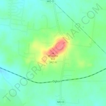
Name: Wiggins Hill topographic map, elevation, terrain.
Location: Wiggins Hill, Saint Francois County, Missouri, United States (37.83834 -90.42323 37.83844 -90.42313)
Average elevation: 293 m
Minimum elevation: 270 m
Maximum elevation: 348 m
Make a donation
Gear up for your next adventure:
As an Amazon Associate, this site earns from qualifying purchases at no extra cost to you.
Other topographic maps
Click on a map to view its topography, its elevation and its terrain.
Bonne Terre
United States > Missouri > Saint Francois County
Bonne Terre is part of the Southeast Missouri Lead District, an area of rolling hills of the Ozark Plateau with elevations up to 300 feet. The ground is mostly red clay over a base of limestone. The area contains the highest concentration of galena (lead(II) sulfide) in the world.
Average elevation: 253 m
Make a donation
Gear up for your next adventure:
As an Amazon Associate, this site earns from qualifying purchases at no extra cost to you.
St. Joe State Park
United States > Missouri > Saint Francois County > Park Hills
Average elevation: 293 m