
Make a donation
Gear up for your next adventure:
As an Amazon Associate, this site earns from qualifying purchases at no extra cost to you.
Kehlegg topographic map
Click on the map to display elevation.
Make a donation
Gear up for your next adventure:
As an Amazon Associate, this site earns from qualifying purchases at no extra cost to you.
Kehlegg
Kehlegg liegt am östlichen Rand des Vorarlberger Rheintals und an den westlichen Ausläufern des Bregenzerwaldgebirges (Hochälpele-Weißenfluh-Gruppe) auf einer Höhe von 794 Metern Seehöhe. Die teilweise noch erhaltene naturnahe Landschaft ist von offenen Flächen, Waldzungen, Solitärbäumen (alten, allein stehenden Obstbäumen, Ahornen und Kastanien) und Flurgehölzen geprägt. Die Landwirtschaft ist auch heute noch prägend für die Siedlungsstruktur des Dorfes. Seit den 1960er Jahren sind auch viele Einfamilienhäuser dazu gekommen. Der dörflich unberührte Charakter am Rande der Stadt Dornbirn hat zu teilweise hohen Grundstückspreisen geführt.
Make a donation
Gear up for your next adventure:
As an Amazon Associate, this site earns from qualifying purchases at no extra cost to you.
About this map
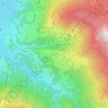
Name: Kehlegg topographic map, elevation, terrain.
Location: Kehlegg, Dornbirn, Bezirk Dornbirn, Vorarlberg, 6857, Österreich (47.38200 9.75785 47.42200 9.79785)
Average elevation: 801 m
Minimum elevation: 430 m
Maximum elevation: 1,372 m
Make a donation
Gear up for your next adventure:
As an Amazon Associate, this site earns from qualifying purchases at no extra cost to you.
Other topographic maps
Click on a map to view its topography, its elevation and its terrain.
Mäander der Dornbirner Ach
Österreich > Vorarlberg > Bezirk Dornbirn > Dornbirn
Average elevation: 407 m