
Make a donation
Gear up for your next adventure:
As an Amazon Associate, this site earns from qualifying purchases at no extra cost to you.
Şanlıurfa topographic map
Click on the map to display elevation.
Make a donation
Gear up for your next adventure:
As an Amazon Associate, this site earns from qualifying purchases at no extra cost to you.
About this map
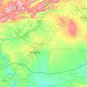
Name: Şanlıurfa topographic map, elevation, terrain.
Location: Şanlıurfa, Southeastern Anatolia Region, Turkey (36.66910 37.83519 38.02052 40.23847)
Average elevation: 720 m
Minimum elevation: 303 m
Maximum elevation: 2,522 m
Make a donation
Gear up for your next adventure:
As an Amazon Associate, this site earns from qualifying purchases at no extra cost to you.
Other topographic maps
Click on a map to view its topography, its elevation and its terrain.
Mount Ararat
Mount Ararat (/ˈærəræt/, ARR-ə-rat; Armenian: Արարատ, romanized: Ararat), also known as Mount Ağrı (Turkish: Ağrı Dağı) or Masis (Armenian: Մասիս), is a snow-capped and dormant compound volcano in eastern Turkey. It consists of two major volcanic cones: Greater Ararat and Little Ararat.…
Average elevation: 4,582 m
Make a donation
Gear up for your next adventure:
As an Amazon Associate, this site earns from qualifying purchases at no extra cost to you.
Make a donation
Gear up for your next adventure:
As an Amazon Associate, this site earns from qualifying purchases at no extra cost to you.