
Make a donation
Gear up for your next adventure:
As an Amazon Associate, this site earns from qualifying purchases at no extra cost to you.
Aguiã topographic map
Click on the map to display elevation.
Make a donation
Gear up for your next adventure:
As an Amazon Associate, this site earns from qualifying purchases at no extra cost to you.
About this map
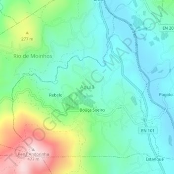
Name: Aguiã topographic map, elevation, terrain.
Location: Aguiã, Arcos de Valdevez, Viana do Castelo, Portugal (41.87347 -8.45906 41.89556 -8.42843)
Average elevation: 159 m
Minimum elevation: 40 m
Maximum elevation: 470 m
Make a donation
Gear up for your next adventure:
As an Amazon Associate, this site earns from qualifying purchases at no extra cost to you.
Other topographic maps
Click on a map to view its topography, its elevation and its terrain.
Bouça dos Homens
Portugal > Viana do Castelo > Arcos de Valdevez > Gavieira
Average elevation: 1,091 m
Senhora do Castelo
Portugal > Viana do Castelo > Arcos de Valdevez > Rio Frio
Average elevation: 224 m
Make a donation
Gear up for your next adventure:
As an Amazon Associate, this site earns from qualifying purchases at no extra cost to you.