
Make a donation
Gear up for your next adventure:
As an Amazon Associate, this site earns from qualifying purchases at no extra cost to you.
Interlaken topographic map
Click on the map to display elevation.
Make a donation
Gear up for your next adventure:
As an Amazon Associate, this site earns from qualifying purchases at no extra cost to you.
About this map
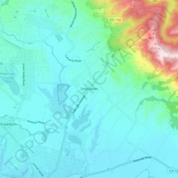
Name: Interlaken topographic map, elevation, terrain.
Location: Interlaken, Santa Cruz County, California, United States (36.91559 -121.76941 36.99001 -121.69718)
Average elevation: 93 m
Minimum elevation: 2 m
Maximum elevation: 529 m
Make a donation
Gear up for your next adventure:
As an Amazon Associate, this site earns from qualifying purchases at no extra cost to you.
Other topographic maps
Click on a map to view its topography, its elevation and its terrain.
The Forest of Nisene Marks State Park
United States > California > Santa Cruz County > Day Valley
Average elevation: 237 m
Make a donation
Gear up for your next adventure:
As an Amazon Associate, this site earns from qualifying purchases at no extra cost to you.
Make a donation
Gear up for your next adventure:
As an Amazon Associate, this site earns from qualifying purchases at no extra cost to you.
Pleasure Point
United States > California > Santa Cruz County > Pleasure Point
Average elevation: 12 m
Make a donation
Gear up for your next adventure:
As an Amazon Associate, this site earns from qualifying purchases at no extra cost to you.
Huckleberry Woods
United States > California > Santa Cruz County > Boulder Creek
Average elevation: 263 m
The Vineyard
United States > California > Santa Cruz County > Bonny Doon > The Vineyard
Average elevation: 426 m
Make a donation
Gear up for your next adventure:
As an Amazon Associate, this site earns from qualifying purchases at no extra cost to you.
Red, White and Blue Beach
United States > California > Santa Cruz County > Gordola
Average elevation: 26 m