
Make a donation
Gear up for your next adventure:
As an Amazon Associate, this site earns from qualifying purchases at no extra cost to you.
Cikembulan topographic map
Click on the map to display elevation.
Make a donation
Gear up for your next adventure:
As an Amazon Associate, this site earns from qualifying purchases at no extra cost to you.
About this map
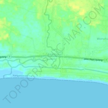
Name: Cikembulan topographic map, elevation, terrain.
Location: Cikembulan, Pangandaran, West Java, Java, 46396, Indonesia (-7.69483 108.58991 -7.65483 108.62991)
Average elevation: 7 m
Minimum elevation: -1 m
Maximum elevation: 19 m
Make a donation
Gear up for your next adventure:
As an Amazon Associate, this site earns from qualifying purchases at no extra cost to you.
Other topographic maps
Click on a map to view its topography, its elevation and its terrain.
Make a donation
Gear up for your next adventure:
As an Amazon Associate, this site earns from qualifying purchases at no extra cost to you.
Pangandaran Beach
Indonesia > West Java > Pangandaran > Desa Pagandaran > Pangandaran
Average elevation: 4 m