
Kloof topographic map
Interactive map
Click on the map to display elevation.
About this map
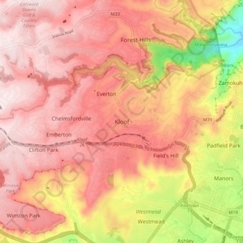
Name: Kloof topographic map, elevation, terrain.
Average elevation: 480 m
Minimum elevation: 101 m
Maximum elevation: 673 m
The further subdivisions and sale of portions of Richmond Farm No. 999 by the Field heirs after 1901 resulted in the birth of Kloof as a residential area: numerous plots were sold to wealthy Durban residents and businessmen, who built country house retreats close to the city, but (due to its 550 m above sea level elevation) removed from the Durban humidity and heat. These were particularly favoured by their wives and children during the long hot summer holidays.