Kelso topographic map
Interactive map
Click on the map to display elevation.
About this map
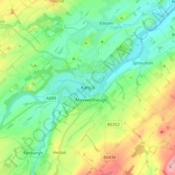
Name: Kelso topographic map, elevation, terrain.
Location: Kelso, Scottish Borders, Scotland, TD5 7HG, United Kingdom (55.55838 -2.47384 55.63838 -2.39384)
Average elevation: 79 m
Minimum elevation: 22 m
Maximum elevation: 210 m
Other topographic maps
Click on a map to view its topography, its elevation and its terrain.
Stow
United Kingdom > Scotland > Scottish Borders
Stow, Scottish Borders, Scotland, TD1 2RE, United Kingdom
Average elevation: 268 m
Blacklaw
United Kingdom > Scotland > Scottish Borders
Blacklaw, Scottish Borders, Scotland, ML12 6QR, United Kingdom
Average elevation: 360 m
Abbey St. Bathans
United Kingdom > Scotland > Scottish Borders
Abbey St. Bathans, Scottish Borders, Scotland, TD11 3TX, United Kingdom
Average elevation: 212 m
West Linton
United Kingdom > Scotland > Scottish Borders
West Linton, Scottish Borders, Scotland, EH46 7ED, United Kingdom
Average elevation: 264 m
Cappercleuch
United Kingdom > Scotland > Scottish Borders
Cappercleuch, Scottish Borders, Scotland, TD7 5LG, United Kingdom
Average elevation: 378 m
Roberton
United Kingdom > Scotland > Scottish Borders > Roberton
Roberton, Scottish Borders, Scotland, TD9 7LX, United Kingdom
Average elevation: 244 m