
Make a donation
Gear up for your next adventure:
As an Amazon Associate, this site earns from qualifying purchases at no extra cost to you.
Andover topographic map
Click on the map to display elevation.
Make a donation
Gear up for your next adventure:
As an Amazon Associate, this site earns from qualifying purchases at no extra cost to you.
About this map
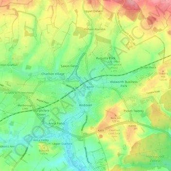
Name: Andover topographic map, elevation, terrain.
Location: Andover, Test Valley, Hampshire, England, United Kingdom (51.19455 -1.53440 51.23710 -1.42111)
Average elevation: 90 m
Minimum elevation: 48 m
Maximum elevation: 151 m
Make a donation
Gear up for your next adventure:
As an Amazon Associate, this site earns from qualifying purchases at no extra cost to you.
Other topographic maps
Click on a map to view its topography, its elevation and its terrain.
Make a donation
Gear up for your next adventure:
As an Amazon Associate, this site earns from qualifying purchases at no extra cost to you.
News Wood
United Kingdom > England > Hampshire > Test Valley > King's Somborne
Average elevation: 93 m
Make a donation
Gear up for your next adventure:
As an Amazon Associate, this site earns from qualifying purchases at no extra cost to you.
Bath Meadows
United Kingdom > England > Hampshire > Test Valley > Wellow > East Wellow
Average elevation: 30 m
Bitterne Grove
United Kingdom > England > Hampshire > Test Valley > Mottisfont > Dunbridge
Average elevation: 39 m
Make a donation
Gear up for your next adventure:
As an Amazon Associate, this site earns from qualifying purchases at no extra cost to you.
Make a donation
Gear up for your next adventure:
As an Amazon Associate, this site earns from qualifying purchases at no extra cost to you.
Make a donation
Gear up for your next adventure:
As an Amazon Associate, this site earns from qualifying purchases at no extra cost to you.
Canada Common
United Kingdom > England > Hampshire > Test Valley > Wellow > Canada
Average elevation: 39 m
Make a donation
Gear up for your next adventure:
As an Amazon Associate, this site earns from qualifying purchases at no extra cost to you.
Make a donation
Gear up for your next adventure:
As an Amazon Associate, this site earns from qualifying purchases at no extra cost to you.
Charlton Down
United Kingdom > England > Hampshire > Test Valley > Wildhern > Charlton Down
Average elevation: 111 m
Make a donation
Gear up for your next adventure:
As an Amazon Associate, this site earns from qualifying purchases at no extra cost to you.
The Bog
United Kingdom > England > Hampshire > Test Valley > Braishfield > Crookhill
Average elevation: 39 m
Rockmoor Pond
United Kingdom > England > Hampshire > Test Valley > Littledown
Average elevation: 208 m
Make a donation
Gear up for your next adventure:
As an Amazon Associate, this site earns from qualifying purchases at no extra cost to you.
Make a donation
Gear up for your next adventure:
As an Amazon Associate, this site earns from qualifying purchases at no extra cost to you.