
Asti topographic map
Interactive map
Click on the map to display elevation.
About this map
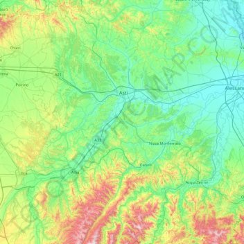
Name: Asti topographic map, elevation, terrain.
Location: Asti, Piedmont, Italy (44.51899 7.88343 45.13300 8.51363)
Average elevation: 261 m
Minimum elevation: 84 m
Maximum elevation: 859 m
Other topographic maps
Click on a map to view its topography, its elevation and its terrain.
Domodossola
Italy > Piedmont > Verbano-Cusio-Ossola
Domodossola, Verbano-Cusio-Ossola, Piedmont, 28845, Italy
Average elevation: 838 m
Valley Pellice
Italy > Piedmont > Torino > Villar Pellice
Valley Pellice, Villar Pellice, Torino, Piedmont, Italy
Average elevation: 1,338 m
Limone Piemonte
Limone Piemonte, Cuneo, Piedmont, 12015, Italy
Average elevation: 1,619 m
La Mandria
Italy > Piedmont > Vercelli > Santhià
La Mandria, Santhià, Vercelli, Piedmont, 13048, Italy
Average elevation: 214 m
F.ne Scaglione
Italy > Piedmont > Cuneo > Santo Stefano Belbo > F.ne Scaglione
F.ne Scaglione, Santo Stefano Belbo, Cuneo, Piedmont, 12053, Italy
Average elevation: 330 m
Torrente Mastallone
Italy > Piedmont > Vercelli > Fobello
Torrente Mastallone, Fobello, Cellio con Breia, Vercelli, Piedmont, 13055, Italy
Average elevation: 1,189 m