
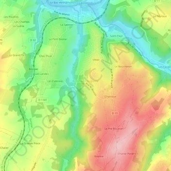
Bosmie-l'Aiguille topographic map
Interactive map
Click on the map to display elevation.
About this map
Name: Bosmie-l'Aiguille topographic map, elevation, terrain.
Average elevation: 286 m
Minimum elevation: 203 m
Maximum elevation: 380 m
Son altitude minimale est de 210 m (la Vienne). Son altitude maximale est de 374 m. La mairie se situe à une altitude de 320 m.
Other topographic maps
Click on a map to view its topography, its elevation and its terrain.
Viblac
France > Nouvelle-Aquitaine > Haute-Vienne > Bosmie-l'Aiguille > Viblac
Viblac, Bosmie-l'Aiguille, Limoges, Haute-Vienne, Nouvelle-Aquitaine, France métropolitaine, 87110, France
Average elevation: 275 m