
Ljubljana topographic map
Interactive map
Click on the map to display elevation.
About this map
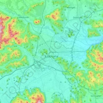
Name: Ljubljana topographic map, elevation, terrain.
Location: Ljubljana, Upravna Enota Ljubljana, Slovenia (45.97406 14.40862 46.14600 14.75533)
Average elevation: 355 m
Minimum elevation: 257 m
Maximum elevation: 885 m
Other topographic maps
Click on a map to view its topography, its elevation and its terrain.
Rogla
Rogla was attested in written sources in 1763–87 as Vitenska Planina and Wittenska Planina. The Slovene name Rogla is derived from the Slovene common noun rogla 'forked tree-covered mountain ridge', referring to the local topography.
Average elevation: 1,366 m
Mangart
Mangart or Mangrt is a mountain in the Julian Alps, located on the border between Italy and Slovenia. With an elevation of 2,679 metres (8,789 ft), it is the fourth-highest peak in Slovenia, after Triglav, Škrlatica and Mali Triglav. It was first climbed in 1794 by the naturalist Franz von Hohenwart. Mangart…
Average elevation: 1,800 m
Triglav
Triglav (pronounced [ˈtɾiːɡlau̯]; German: Terglau; Italian: Tricorno), with an elevation of 2,863.65 metres (9,395 ft 2+1⁄8 in), is the highest mountain in Slovenia and the highest peak of the Julian Alps. The mountain is the pre-eminent symbol of the Slovene nation, appearing on the coat of arms and…
Average elevation: 2,161 m
Kras
It lies between the Vipava Valley, the low hills surrounding the valley, the westernmost part of the Brkini Hills, northern Istria, and the Gulf of Trieste. The western edge of the plateau also marks the traditional ethnic border between Italians and Slovenes. The region gave its name to karst topography. For…
Average elevation: 423 m
Triglav
Triglav (pronounced [ˈtɾiːɡlau̯]; German: Terglau; Italian: Tricorno), with an elevation of 2,863.65 metres (9,395.2 ft), is the highest mountain in Slovenia and the highest peak of the Julian Alps. The mountain is the pre-eminent symbol of the Slovene nation, appearing on the coat of arms and flag of…
Average elevation: 2,161 m
Gornji Slaveči
The name Gornji Slaveči (literally, 'upper Slaveči') contrasts with the name Dolnji Slaveči (literally, 'lower Slaveči'), a village in the neighboring Municipality of Grad. Dolnji Slaveči lies about 20 meters (66 ft) lower in elevation than Gornji Slaveči.
Average elevation: 287 m
Strmec na Predelu
Slovenia > Bovec > Log pod Mangartom
Strmec na Predelu (pronounced [ˈstəɾməts na pɾɛˈdeːlu]; Italian: Bretto di Sopra) is a settlement in the Municipality of Bovec in the Littoral region of Slovenia. It lies on the road to the Predel Pass. Another road, distinguished by being the road built at the highest elevation in Slovenia, splits off…
Average elevation: 1,141 m
Dolnji Lakoš / Alsólakos
The name Dolnji Lakoš literally means 'lower Lakoš', contrasting with neighboring Gornji Lakoš (literally, 'upper Lakoš'), which is about 1 meter (3 ft 3 in) higher in elevation. The Hungarian name Alsólakos semantically corresponds to the Slovene name and also means 'lower Lakoš'. In the 1380s, the…
Average elevation: 168 m