
Thank you for supporting this site ❤️
Make a donation
Make a donation
Gear up for your next adventure:
As an Amazon Associate, this site earns from qualifying purchases at no extra cost to you.
Lauricocha topographic map
Click on the map to display elevation.
Thank you for supporting this site ❤️
Make a donation
Make a donation
Gear up for your next adventure:
As an Amazon Associate, this site earns from qualifying purchases at no extra cost to you.
About this map
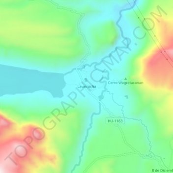
Name: Lauricocha topographic map, elevation, terrain.
Location: Lauricocha, San Miguel de Cauri, Lauricocha, Huánuco, Perú (-10.33550 -76.67859 -10.29550 -76.63859)
Average elevation: 4,002 m
Minimum elevation: 3,819 m
Maximum elevation: 4,402 m
Thank you for supporting this site ❤️
Make a donation
Make a donation
Gear up for your next adventure:
As an Amazon Associate, this site earns from qualifying purchases at no extra cost to you.