
Narita topographic map
Interactive map
Click on the map to display elevation.
About this map
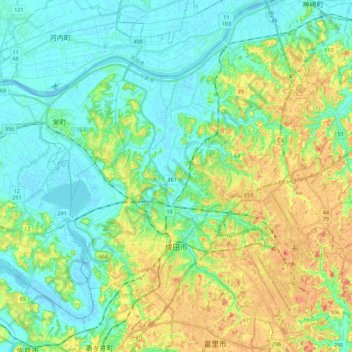
Name: Narita topographic map, elevation, terrain.
Location: Narita, Chiba Prefecture, Japan (35.72327 140.24915 35.90237 140.47248)
Average elevation: 19 m
Minimum elevation: -2 m
Maximum elevation: 58 m
Other topographic maps
Click on a map to view its topography, its elevation and its terrain.
東京湾
Japan > Kanagawa Prefecture > Kawasaki
The shoal between Cape Futtsu in Chiba Prefecture and Cape Honmaku in Yokohama is known as Nakanose, and has a depth of 20 metres (66 ft). North of this area the bay has a depth of 40 metres (130 ft) and an uncomplicated underwater topography. Areas south of Nakanose are significantly deeper moving towards the…
Average elevation: 0 m