
Make a donation
Gear up for your next adventure:
As an Amazon Associate, this site earns from qualifying purchases at no extra cost to you.
Aviano topographic map
Click on the map to display elevation.
Make a donation
Gear up for your next adventure:
As an Amazon Associate, this site earns from qualifying purchases at no extra cost to you.
Aviano
Although the village is located at the foot of the Dolomites, the municipality extends to an altitude of 2,251 metres (7,385 feet) above sea level (Cimon del Cavallo peak).
Make a donation
Gear up for your next adventure:
As an Amazon Associate, this site earns from qualifying purchases at no extra cost to you.
About this map
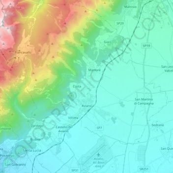
Name: Aviano topographic map, elevation, terrain.
Location: Aviano, Pordenone, Friuli – Venezia Giulia, 33081, Italy (46.01905 12.48782 46.14740 12.67787)
Average elevation: 475 m
Minimum elevation: 33 m
Maximum elevation: 2,217 m
Make a donation
Gear up for your next adventure:
As an Amazon Associate, this site earns from qualifying purchases at no extra cost to you.