
Kłodzko County topographic map
Interactive map
Click on the map to display elevation.
About this map
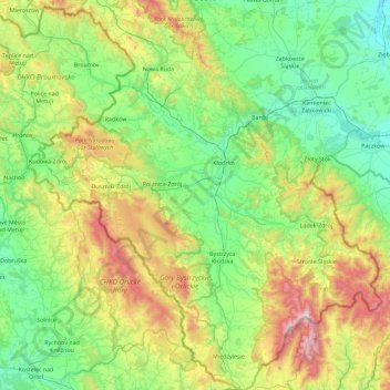
Name: Kłodzko County topographic map, elevation, terrain.
Location: Kłodzko County, Lower Silesian Voivodeship, Poland (50.09633 16.19558 50.68110 17.02831)
Average elevation: 509 m
Minimum elevation: 184 m
Maximum elevation: 1,422 m
Other topographic maps
Click on a map to view its topography, its elevation and its terrain.
Wrocław
Poland > Lower Silesian Voivodeship
Wrocław, Lower Silesian Voivodeship, Poland
Average elevation: 124 m
Czech
Poland > Lower Silesian Voivodeship > Kłodzko County > Łężyce
Czech, Łężyce, gmina Szczytna, Kłodzko County, Lower Silesian Voivodeship, Poland
Average elevation: 669 m
Jelenia Góra County
Poland > Lower Silesian Voivodeship
Jelenia Góra County, Lower Silesian Voivodeship, 58-512, Poland
Average elevation: 606 m
Polanica-Zdrój
Poland > Lower Silesian Voivodeship > Polanica-Zdrój
Polanica-Zdrój, powiat kłodzki, Lower Silesian Voivodeship, 57-320, Poland
Average elevation: 458 m
Kłodzko
Poland > Lower Silesian Voivodeship > Kłodzko
Kłodzko, powiat kłodzki, Lower Silesian Voivodeship, 57-300, Poland
Average elevation: 332 m