
Make a donation
Gear up for your next adventure:
As an Amazon Associate, this site earns from qualifying purchases at no extra cost to you.
Christiansburg topographic map
Click on the map to display elevation.
Make a donation
Gear up for your next adventure:
As an Amazon Associate, this site earns from qualifying purchases at no extra cost to you.
About this map
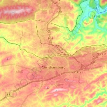
Name: Christiansburg topographic map, elevation, terrain.
Location: Christiansburg, Montgomery County, Virginia, United States (37.10702 -80.45340 37.18082 -80.31440)
Average elevation: 620 m
Minimum elevation: 433 m
Maximum elevation: 757 m
Make a donation
Gear up for your next adventure:
As an Amazon Associate, this site earns from qualifying purchases at no extra cost to you.
Other topographic maps
Click on a map to view its topography, its elevation and its terrain.
Ramble Ridge
United States > Virginia > Montgomery County > Blacksburg > Ramble Ridge
Average elevation: 632 m
Southgate
United States > Virginia > Montgomery County > Blacksburg > Southgate
Average elevation: 643 m
Make a donation
Gear up for your next adventure:
As an Amazon Associate, this site earns from qualifying purchases at no extra cost to you.