
Make a donation
Gear up for your next adventure:
As an Amazon Associate, this site earns from qualifying purchases at no extra cost to you.
Belgern topographic map
Click on the map to display elevation.
Make a donation
Gear up for your next adventure:
As an Amazon Associate, this site earns from qualifying purchases at no extra cost to you.
Belgern
Belgern ist ein Ortsteil der Stadt Belgern-Schildau im Landkreis Nordsachsen in Sachsen (Deutschland). Er liegt auf einer Anhöhe am linken Elbufer.
Make a donation
Gear up for your next adventure:
As an Amazon Associate, this site earns from qualifying purchases at no extra cost to you.
About this map
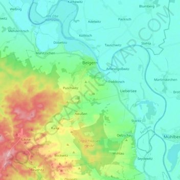
Name: Belgern topographic map, elevation, terrain.
Location: Belgern, Nordsachsen, Sachsen, 04874, Deutschland (51.40601 13.02107 51.52361 13.20414)
Average elevation: 113 m
Minimum elevation: 79 m
Maximum elevation: 211 m
Make a donation
Gear up for your next adventure:
As an Amazon Associate, this site earns from qualifying purchases at no extra cost to you.
Other topographic maps
Click on a map to view its topography, its elevation and its terrain.