
Thank you for supporting this site ❤️
Make a donation
Make a donation
Gear up for your next adventure:
As an Amazon Associate, this site earns from qualifying purchases at no extra cost to you.
Olmsted topographic map
Click on the map to display elevation.
Thank you for supporting this site ❤️
Make a donation
Make a donation
Gear up for your next adventure:
As an Amazon Associate, this site earns from qualifying purchases at no extra cost to you.
About this map
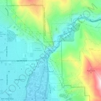
Name: Olmsted topographic map, elevation, terrain.
Location: Olmsted, Orem, Utah County, Utah, 84604, United States (40.29607 -111.67404 40.33607 -111.63404)
Average elevation: 1,594 m
Minimum elevation: 1,448 m
Maximum elevation: 1,991 m
Thank you for supporting this site ❤️
Make a donation
Make a donation
Gear up for your next adventure:
As an Amazon Associate, this site earns from qualifying purchases at no extra cost to you.