
Make a donation
Gear up for your next adventure:
As an Amazon Associate, this site earns from qualifying purchases at no extra cost to you.
Lenggries topographic map
Click on the map to display elevation.
Make a donation
Gear up for your next adventure:
As an Amazon Associate, this site earns from qualifying purchases at no extra cost to you.
Lenggries
Lenggries sits on the Isar River before it transitions into the Alpine foothills. To the east are the Tegernsee Mountains, to the west lies the home mountain of Lenggries known as the Brauneck with an elevation of over 1,555 meters above sea level. The Brauneck is a well known ski area tied together by lifts. The town of Lenggries sits 700 meters above sea level.
Make a donation
Gear up for your next adventure:
As an Amazon Associate, this site earns from qualifying purchases at no extra cost to you.
About this map
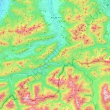
Name: Lenggries topographic map, elevation, terrain.
Average elevation: 1,096 m
Minimum elevation: 615 m
Maximum elevation: 2,080 m
Make a donation
Gear up for your next adventure:
As an Amazon Associate, this site earns from qualifying purchases at no extra cost to you.
Other topographic maps
Click on a map to view its topography, its elevation and its terrain.