
Milton Township topographic map
Interactive map
Click on the map to display elevation.
About this map
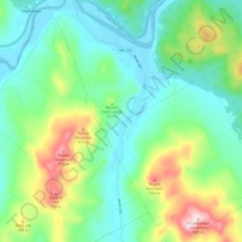
Name: Milton Township topographic map, elevation, terrain.
Location: Milton Township, Oxford County, Maine, 04219, United States (44.42292 -70.66097 44.49898 -70.55012)
Average elevation: 309 m
Minimum elevation: 182 m
Maximum elevation: 629 m
Other topographic maps
Click on a map to view its topography, its elevation and its terrain.
Sugarloaf
United States > Maine > Oxford County > Dixfield
Sugarloaf, Dixfield, Oxford County, Maine, 04224, United States
Average elevation: 237 m
Greenwood
United States > Maine > Oxford County
Greenwood, Oxford County, Maine, 04255, United States
Average elevation: 295 m
Pleasant Lake
United States > Maine > Oxford County > Otisfield
Pleasant Lake, Otisfield, Oxford County, Maine, 04270, United States
Average elevation: 140 m
Paris
United States > Maine > Oxford County
Paris, Oxford County, Maine, 04281, United States
Average elevation: 207 m
Woodstock
United States > Maine > Oxford County
Woodstock, Oxford County, Maine, 04219, United States
Average elevation: 316 m
Rumford
United States > Maine > Oxford County
Rumford, Oxford County, Maine, 04276, United States
Average elevation: 279 m
Upton
United States > Maine > Oxford County
Upton, Oxford County, Maine, 04261, United States
Average elevation: 448 m
West Paris
United States > Maine > Oxford County
West Paris, Oxford County, Maine, 04289, United States
Average elevation: 234 m
Bethel
United States > Maine > Oxford County
Bethel, Oxford County, Maine, 04217, United States
Average elevation: 310 m
Stow
United States > Maine > Oxford County
Stow, Oxford County, Maine, 04037, United States
Average elevation: 308 m
Plumbago Mountain
United States > Maine > Oxford County > Newry
Plumbago Mountain, Newry, Oxford County, Maine, 04261, United States
Average elevation: 618 m
Denmark
United States > Maine > Oxford County
Denmark, Oxford County, Maine, 04022, United States
Average elevation: 174 m
South Paris
United States > Maine > Oxford County > Paris
South Paris, Paris, Oxford County, Maine, 04281, United States
Average elevation: 155 m
Sweden
United States > Maine > Oxford County
Sweden, Oxford County, Maine, 04040, United States
Average elevation: 185 m
Norway
United States > Maine > Oxford County
Norway, Oxford County, Maine, 04268, United States
Average elevation: 180 m