
Thank you for supporting this site ❤️
Make a donation
Make a donation
Gear up for your next adventure:
As an Amazon Associate, this site earns from qualifying purchases at no extra cost to you.
Finsteraarhorn topographic map
Click on the map to display elevation.
Thank you for supporting this site ❤️
Make a donation
Make a donation
Gear up for your next adventure:
As an Amazon Associate, this site earns from qualifying purchases at no extra cost to you.
About this map
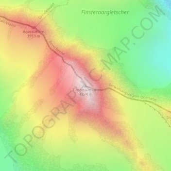
Name: Finsteraarhorn topographic map, elevation, terrain.
Location: Finsteraarhorn, Fieschertal, Goms, Vallese, Svizzera (46.53730 8.12606 46.53740 8.12616)
Average elevation: 3,420 m
Minimum elevation: 2,676 m
Maximum elevation: 4,205 m
Thank you for supporting this site ❤️
Make a donation
Make a donation
Gear up for your next adventure:
As an Amazon Associate, this site earns from qualifying purchases at no extra cost to you.
Other topographic maps
Click on a map to view its topography, its elevation and its terrain.