Make a donation
Gear up for your next adventure:
As an Amazon Associate, this site earns from qualifying purchases at no extra cost to you.
Lone Tree topographic map
Click on the map to display elevation.
Make a donation
Gear up for your next adventure:
As an Amazon Associate, this site earns from qualifying purchases at no extra cost to you.
Lone Tree
Lone Tree is located on the northern border of Douglas County, directly adjacent to Arapahoe County, approximately 18 miles (29 km) south of downtown Denver. Neighboring communities include Centennial to the north, Highlands Ranch to the west, and Parker to the southeast. The Meridian International Business Center, a major office and business park, lies immediately north of the city in unincorporated Arapahoe County. According to the United States Census Bureau, the city has a total area of 9.81 square miles (25.4 km²), all of it land, at an elevation of 6,010 feet (1,832 m).
Make a donation
Gear up for your next adventure:
As an Amazon Associate, this site earns from qualifying purchases at no extra cost to you.
About this map
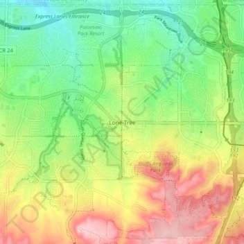
Name: Lone Tree topographic map, elevation, terrain.
Location: Lone Tree, Douglas County, Colorado, 80124, United States (39.50710 -104.90935 39.56648 -104.82991)
Average elevation: 1,818 m
Minimum elevation: 1,730 m
Maximum elevation: 1,938 m
Make a donation
Gear up for your next adventure:
As an Amazon Associate, this site earns from qualifying purchases at no extra cost to you.
Other topographic maps
Click on a map to view its topography, its elevation and its terrain.
Make a donation
Gear up for your next adventure:
As an Amazon Associate, this site earns from qualifying purchases at no extra cost to you.
Make a donation
Gear up for your next adventure:
As an Amazon Associate, this site earns from qualifying purchases at no extra cost to you.
Make a donation
Gear up for your next adventure:
As an Amazon Associate, this site earns from qualifying purchases at no extra cost to you.
Make a donation
Gear up for your next adventure:
As an Amazon Associate, this site earns from qualifying purchases at no extra cost to you.
Hidden Mesa Open Space
United States > Colorado > Douglas County > Castle Rock
Average elevation: 1,902 m
Make a donation
Gear up for your next adventure:
As an Amazon Associate, this site earns from qualifying purchases at no extra cost to you.
