
Thank you for supporting this site ❤️
Make a donation
Make a donation
Gear up for your next adventure:
As an Amazon Associate, this site earns from qualifying purchases at no extra cost to you.
Bexiga topographic map
Click on the map to display elevation.
Thank you for supporting this site ❤️
Make a donation
Make a donation
Gear up for your next adventure:
As an Amazon Associate, this site earns from qualifying purchases at no extra cost to you.
About this map
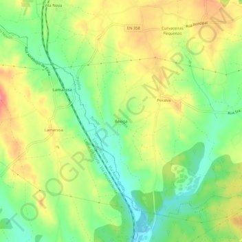
Name: Bexiga topographic map, elevation, terrain.
Location: Bexiga, Paialvo, Tomar, Santarém, 2305-518, Portugal (39.50266 -8.47634 39.54266 -8.43634)
Average elevation: 80 m
Minimum elevation: 44 m
Maximum elevation: 119 m
Thank you for supporting this site ❤️
Make a donation
Make a donation
Gear up for your next adventure:
As an Amazon Associate, this site earns from qualifying purchases at no extra cost to you.
Other topographic maps
Click on a map to view its topography, its elevation and its terrain.
Mata Nacional dos Sete Montes
Portugal > Santarém > Tomar > Casal dos Peixinhos
Average elevation: 102 m