
Make a donation
Gear up for your next adventure:
As an Amazon Associate, this site earns from qualifying purchases at no extra cost to you.
Kirchen topographic map
Click on the map to display elevation.
Make a donation
Gear up for your next adventure:
As an Amazon Associate, this site earns from qualifying purchases at no extra cost to you.
About this map
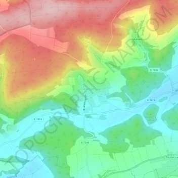
Name: Kirchen topographic map, elevation, terrain.
Average elevation: 619 m
Minimum elevation: 525 m
Maximum elevation: 752 m
Make a donation
Gear up for your next adventure:
As an Amazon Associate, this site earns from qualifying purchases at no extra cost to you.
Other topographic maps
Click on a map to view its topography, its elevation and its terrain.
Erbstetten
Deutschland > Baden-Württemberg > Alb-Donau-Kreis > Ehingen (Donau)
Average elevation: 631 m
Frankenhofen
Deutschland > Baden-Württemberg > Alb-Donau-Kreis > Ehingen (Donau)
Average elevation: 725 m
Altbierlingen
Deutschland > Baden-Württemberg > Alb-Donau-Kreis > Ehingen (Donau)
Average elevation: 511 m
Make a donation
Gear up for your next adventure:
As an Amazon Associate, this site earns from qualifying purchases at no extra cost to you.
Rißtissen
Deutschland > Baden-Württemberg > Alb-Donau-Kreis > Ehingen (Donau)
Average elevation: 494 m
89584
Deutschland > Baden-Württemberg > Alb-Donau-Kreis > Ehingen (Donau) > Kirchen
Average elevation: 614 m
Make a donation
Gear up for your next adventure:
As an Amazon Associate, this site earns from qualifying purchases at no extra cost to you.