
Infias topographic map
Interactive map
Click on the map to display elevation.
About this map
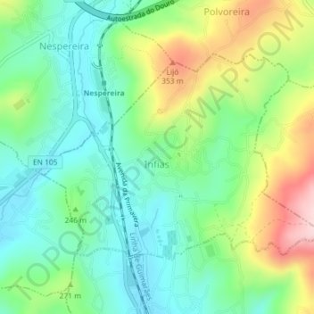
Name: Infias topographic map, elevation, terrain.
Location: Infias, Vizela, Braga, Portugal (41.38794 -8.32652 41.40578 -8.29420)
Average elevation: 233 m
Minimum elevation: 151 m
Maximum elevation: 396 m
Other topographic maps
Click on a map to view its topography, its elevation and its terrain.
São Miguel
São Miguel, Caldas de Vizela (São Miguel e São João), Vizela, Braga, Portugal
Average elevation: 223 m
São Bento das Peras
São Bento das Peras, Vizela, Braga, 4815-596, Portugal
Average elevation: 289 m