
Make a donation
Gear up for your next adventure:
As an Amazon Associate, this site earns from qualifying purchases at no extra cost to you.
Puno topographic map
Click on the map to display elevation.
Make a donation
Gear up for your next adventure:
As an Amazon Associate, this site earns from qualifying purchases at no extra cost to you.
Puno
As Puno is located at such a high elevation, it experiences more extreme weather conditions than would be expected for its tropical latitude. The average annual temperature is about 8.4 °C (47.1 °F), and the weather never gets overly warm. During the winter months from June to August, night-time temperatures usually drop well below 0 °C (32 °F). At this high altitude, the rays of the sun are very strong. Most of the annual precipitation falls during the southern hemisphere summer, with the winter months being very dry.
Make a donation
Gear up for your next adventure:
As an Amazon Associate, this site earns from qualifying purchases at no extra cost to you.
About this map
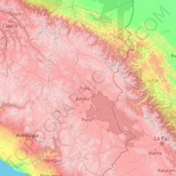
Name: Puno topographic map, elevation, terrain.
Location: Puno, Peru (-17.29525 -71.11809 -13.00413 -68.79549)
Average elevation: 3,150 m
Minimum elevation: 0 m
Maximum elevation: 6,251 m
Make a donation
Gear up for your next adventure:
As an Amazon Associate, this site earns from qualifying purchases at no extra cost to you.