
Tucson topographic map
Interactive map
Click on the map to display elevation.
About this map
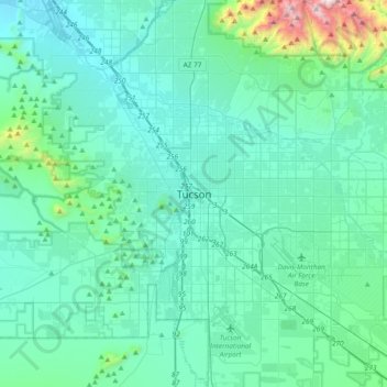
Name: Tucson topographic map, elevation, terrain.
Location: Tucson, Pima County, Arizona, 85701, United States (32.06288 -111.13485 32.38288 -110.81485)
Average elevation: 836 m
Minimum elevation: 634 m
Maximum elevation: 2,313 m
The city's elevation is 2,643 ft (806 m) above sea level (as measured at the Tucson International Airport). Tucson is on an alluvial plain in the Sonoran Desert, surrounded by five minor ranges of mountains: the Santa Catalina Mountains and the Tortolita Mountains to the north, the Santa Rita Mountains to the south, the Rincon Mountains to the east, and the Tucson Mountains to the west. The high point of the Santa Catalina Mountains is 9,157 ft (2,791 m) Mount Lemmon, the southernmost ski destination in the continental U.S., while the Tucson Mountains include 4,687 ft (1,429 m) Wasson Peak. The highest point in the area is Mount Wrightson, found in the Santa Rita Mountains at 9,453 ft (2,881 m) above sea level.
Other topographic maps
Click on a map to view its topography, its elevation and its terrain.
Agua Caliente Wash
United States > Arizona > Pima County > Tucson
Agua Caliente Wash, Powder Horn Ranch, Tucson, Pima County, Arizona, United States
Average elevation: 791 m
Drexel Heights
United States > Arizona > Pima County > Tucson
Drexel Heights, Tucson, Pima County, Arizona, United States
Average elevation: 786 m
Catalina Foothills
United States > Arizona > Pima County > Tucson
Catalina Foothills, Tucson, Pima County, Arizona, United States
Average elevation: 949 m
Mitchell Park
United States > Arizona > Pima County > Tucson
Mitchell Park, Mountain 1st Avenue, Tucson, Pima County, Arizona, United States
Average elevation: 731 m
Iron Horse
United States > Arizona > Pima County > Tucson
Iron Horse, Tucson, Pima County, Arizona, United States
Average elevation: 736 m
Archer Lake
United States > Arizona > Pima County > Tucson
Archer Lake, Tucson, Pima County, Arizona, United States
Average elevation: 695 m
Rillito River
United States > Arizona > Pima County > Tucson
Rillito River, Tucson, Pima County, Arizona, United States
Average elevation: 790 m