
Thank you for supporting this site ❤️
Make a donation
Make a donation
Gear up for your next adventure:
As an Amazon Associate, this site earns from qualifying purchases at no extra cost to you.
Wald-Michelbach topographic map
Click on the map to display elevation.
Thank you for supporting this site ❤️
Make a donation
Make a donation
Gear up for your next adventure:
As an Amazon Associate, this site earns from qualifying purchases at no extra cost to you.
About this map
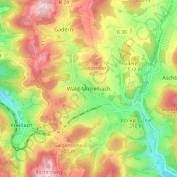
Name: Wald-Michelbach topographic map, elevation, terrain.
Location: Wald-Michelbach, Kreis Bergstraße, Hesse, 69483, Germany (49.55342 8.80292 49.59342 8.84292)
Average elevation: 396 m
Minimum elevation: 272 m
Maximum elevation: 522 m
Thank you for supporting this site ❤️
Make a donation
Make a donation
Gear up for your next adventure:
As an Amazon Associate, this site earns from qualifying purchases at no extra cost to you.