
Make a donation
Gear up for your next adventure:
As an Amazon Associate, this site earns from qualifying purchases at no extra cost to you.
Queens Hill topographic map
Click on the map to display elevation.
Make a donation
Gear up for your next adventure:
As an Amazon Associate, this site earns from qualifying purchases at no extra cost to you.
About this map
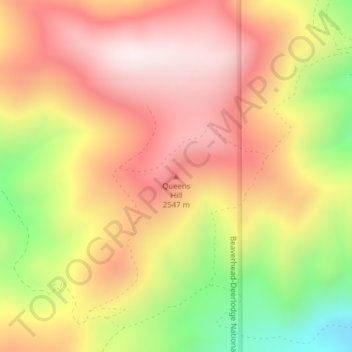
Name: Queens Hill topographic map, elevation, terrain.
Location: Queens Hill, Madison County, Montana, United States (45.65682 -111.97448 45.65692 -111.97438)
Average elevation: 2,419 m
Minimum elevation: 2,028 m
Maximum elevation: 2,699 m
Make a donation
Gear up for your next adventure:
As an Amazon Associate, this site earns from qualifying purchases at no extra cost to you.
Other topographic maps
Click on a map to view its topography, its elevation and its terrain.
Axolotl Lakes Wilderness Study Area
United States > Montana > Madison County
Average elevation: 2,351 m
Make a donation
Gear up for your next adventure:
As an Amazon Associate, this site earns from qualifying purchases at no extra cost to you.