
Bandung City topographic map
Interactive map
Click on the map to display elevation.
Bandung City
Bandung, the capital of West Java province, located about 180 kilometres (110 mi) southeast of Jakarta. Its elevation is 768 metres (2,520 ft) above sea level and is surrounded by up to 2,400 metres (7,900 feet) high Late Tertiary and Quaternary volcanic terrain. The 400 km2 flat of central Bandung plain is situated in the middle of 2,340.88 square kilometres (903.82 sq mi) wide of the Bandung Basin; the basin comprises Bandung, the Cimahi city, part of Bandung Regency, part of West Bandung Regency, and part of Sumedang Regency. The basin's main river is the Citarum; one of its branches, the Cikapundung, divides Bandung from north to south before it merges with Citarum again in Dayeuhkolot. The Bandung Basin is an essential source of water for potable water, irrigation, and fisheries, with its 6,147 million m3 (217.1 billion cu ft) of groundwater being a significant reservoir for the city. The northern section of Bandung is hillier than other parts of the city, and the unique truncated flat-peak shape of the Tangkuban Perahu volcano (Tangkuban Perahu literally means 'upside-down boat') can be seen from the city to the north. Long-term volcanic activity has created fertile andisol soil in the north, suitable for intensive rice, fruit, tea, tobacco, and coffee plantations. In the south and east, alluvial soils deposited by the Cikapundung river predominate.
About this map
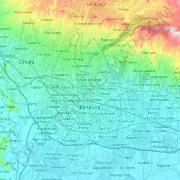
Name: Bandung City topographic map, elevation, terrain.
Location: Bandung City, West Java, Java, Indonesia (-6.96975 107.54536 -6.83685 107.73952)
Average elevation: 824 m
Minimum elevation: 642 m
Maximum elevation: 1,624 m
Other topographic maps
Click on a map to view its topography, its elevation and its terrain.
Pangrango
Indonesia > West Java > Sukabumi
The Mandalawangi peak of the mountain is a tripoint where the borders of Bogor, Cianjur, and Sukabumi Regencies meet. It is the second-highest mountain in West Java after Mount Cereme. Mount Pangrango ranked 26th of the Ribus of Indonesia with a topographic prominence of 2,426 m (7,959 ft). The mountain is…
Average elevation: 2,491 m
Patenggang Lake
Indonesia > West Java > Kabupaten Bandung > Rancabali > Bauan
Patenggang Lake (Indonesian: Situ Patenggang) is a lake located in the area of natural tourist attractions in the southern Bandung City, West Java, Indonesia, to be exact it is in Ciwidey village. Located at an altitude of 1600 meters above sea level, this lake has a very exotic landscape. The lake is spread…
Average elevation: 1,715 m
Ciliwung
Mean rainfall reaches 3,125 mm, with a mean annual discharge of 16 m3/s as measured at Ciliwung Ratujaya observation station (231 km2). With such topographical, geological, and hydrological features, the Ciliwung River is often overflowing and inundating parts of Jakarta. The population along the Ciliwung…
Average elevation: 229 m