
青岛市 topographic map
Interactive map
Click on the map to display elevation.
About this map
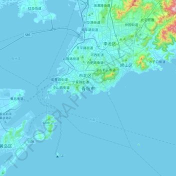
Name: 青岛市 topographic map, elevation, terrain.
Location: 青岛市, 市南区, 青岛市, 山东省, 266001, 中国 (35.90380 120.21814 36.22380 120.53814)
Average elevation: 25 m
Minimum elevation: -5 m
Maximum elevation: 708 m
青岛市地势东高西低、南北隆起、中部低平,呈凹字形。山地约占总面积的15.5 %(主城区共有37个自然山地,占地约39 km²),丘陵占25.1 %,平原占37.7 %,洼地占21.7 %。分出明显的3个地形区:南部剥蚀中低山丘陵区、北部剥蚀低山丘陵区和中部胶莱平原区。这3个地形区基本与3个地质三级构造单元相对应。
Other topographic maps
Click on a map to view its topography, its elevation and its terrain.