
Make a donation
Gear up for your next adventure:
As an Amazon Associate, this site earns from qualifying purchases at no extra cost to you.
Grisons topographic map
Click on the map to display elevation.
Make a donation
Gear up for your next adventure:
As an Amazon Associate, this site earns from qualifying purchases at no extra cost to you.
Grisons
The Grisons lies fully within the Alps, with elevations above sea-level ranging from 260 to 4,049 metres (853 to 13,284 ft). It is both one of the highest and lowest cantons, and the second-highest when considering mean elevation. As a consequence, its topography is extremely rugged and many of the highest settlements in the country (and Europe) are found there, notably in the Upper Engadin. The mountains are numerous; well over 1,000 summits are in the canton. The highest is Piz Bernina, closely followed by numerous peaks in the homonymous range. Other prominent mountains are Piz Russein, Piz Kesch, Calanda, Aroser Rothorn and Rheinwaldhorn, see list of mountains of Graubünden for a more exhaustive list. The canton includes numerous subranges of the Alps other than the Bernina. These are the Albula, the Bregaglia, the Glarus, the Gotthard, the Lepontine, the Livigno, the Plessur, the Oberhalbstein, the Ortler, the Rätikon, the Samnaun, the Sesvenna and the Silvretta ranges.
Make a donation
Gear up for your next adventure:
As an Amazon Associate, this site earns from qualifying purchases at no extra cost to you.
About this map
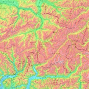
Name: Grisons topographic map, elevation, terrain.
Location: Grisons, Switzerland (46.16918 8.65106 47.06515 10.49229)
Average elevation: 1,737 m
Minimum elevation: 189 m
Maximum elevation: 4,001 m
Make a donation
Gear up for your next adventure:
As an Amazon Associate, this site earns from qualifying purchases at no extra cost to you.
Other topographic maps
Click on a map to view its topography, its elevation and its terrain.
Make a donation
Gear up for your next adventure:
As an Amazon Associate, this site earns from qualifying purchases at no extra cost to you.
Make a donation
Gear up for your next adventure:
As an Amazon Associate, this site earns from qualifying purchases at no extra cost to you.
Ruins
Switzerland > Ticino > Distretto di Lugano > Tresa > Monteggio > Cassinone
Average elevation: 476 m
Make a donation
Gear up for your next adventure:
As an Amazon Associate, this site earns from qualifying purchases at no extra cost to you.
Monte Rosa
Switzerland > Wallis > Visp > Zermatt
The peak is distinguished by the name Dufourspitze (in German, lit. Dufour Peak; French: Pointe Dufour, Italian: Punta Dufour). This replaced the former name Höchste Spitze (English: Highest Peak) that was indicated on the Swiss maps before the Federal Council, on January 28, 1863, decided to rename the…
Average elevation: 4,033 m
Make a donation
Gear up for your next adventure:
As an Amazon Associate, this site earns from qualifying purchases at no extra cost to you.
Oeschinen Lake
Switzerland > Bern > Frutigen-Niedersimmental administrative district > Kandersteg
Oeschinen Lake (German: Oeschinensee) is a lake in the Bernese Oberland, Switzerland, 4 kilometres (2.5 mi) east of Kandersteg in the Oeschinen valley. At an elevation of 1,578 metres (5,177 ft), it has a surface area of 1.1147 square kilometres (0.4304 sq mi). Its maximum depth is 56 metres (184 ft).
Average elevation: 1,918 m
Sankt Stephan
Switzerland > Bern > Obersimmental-Saanen administrative district > St. Stephan
Average elevation: 1,310 m
Brienz
Switzerland > Bern > Interlaken-Oberhasli administrative district > Brienz (BE)
Average elevation: 810 m
Make a donation
Gear up for your next adventure:
As an Amazon Associate, this site earns from qualifying purchases at no extra cost to you.
Jungfrau
Switzerland > Bern > Interlaken-Oberhasli administrative district > Lauterbrunnen
The difference of altitude between the deep valley of Lauterbrunnen (800 m or 2,600 ft) and the summit is particularly visible from the area of Mürren. From the valley floor, west of the massif, the altitude gain is more than 3 km (1.9 mi) for a horizontal distance of 4 km (2.5 mi).
Average elevation: 3,401 m
Make a donation
Gear up for your next adventure:
As an Amazon Associate, this site earns from qualifying purchases at no extra cost to you.
Blüemlisalp
Switzerland > Appenzell Innerrhoden > Schwende-Rüte > Wasserauen
Average elevation: 1,208 m
Make a donation
Gear up for your next adventure:
As an Amazon Associate, this site earns from qualifying purchases at no extra cost to you.
Gimmelwald
Switzerland > Bern > Interlaken-Oberhasli administrative district
Average elevation: 1,564 m
Make a donation
Gear up for your next adventure:
As an Amazon Associate, this site earns from qualifying purchases at no extra cost to you.
Jungfrau
Switzerland > Bern > Interlaken-Oberhasli administrative district > Lauterbrunnen
The difference of altitude between the deep valley of Lauterbrunnen (800 m or 2,600 ft) and the summit is particularly visible from the area of Mürren. From the valley floor, west of the massif, the altitude gain is more than 3 km (1.9 mi) for a horizontal distance of 4 km (2.5 mi).
Average elevation: 3,401 m
Make a donation
Gear up for your next adventure:
As an Amazon Associate, this site earns from qualifying purchases at no extra cost to you.
Make a donation
Gear up for your next adventure:
As an Amazon Associate, this site earns from qualifying purchases at no extra cost to you.
Lausanne
Switzerland > Vaud > District de Lausanne > Lausanne
The most important geographical feature of the area surrounding Lausanne is Lake Geneva (Lac Léman in French). Lausanne is built on the southern slope of the Swiss plateau, with a difference in elevation of about 500 metres (1,640 ft) between the lakeshore at Ouchy and its northern edge bordering Le…
Average elevation: 577 m
Make a donation
Gear up for your next adventure:
As an Amazon Associate, this site earns from qualifying purchases at no extra cost to you.
Wildhaus
Switzerland > St. Gallen > Wahlkreis Toggenburg > Wildhaus-Alt St. Johann
Average elevation: 1,244 m
Reichenbach im Kandertal
Switzerland > Bern > Frutigen-Niedersimmental administrative district
Average elevation: 1,906 m
Make a donation
Gear up for your next adventure:
As an Amazon Associate, this site earns from qualifying purchases at no extra cost to you.
Monte Rosa
Switzerland > Wallis > Visp > Zermatt
The peak is distinguished by the name Dufourspitze (in German, lit. Dufour Peak; French: Pointe Dufour, Italian: Punta Dufour). This replaced the former name Höchste Spitze (English: Highest Peak) that was indicated on the Swiss maps before the Federal Council, on January 28, 1863, decided to rename the…
Average elevation: 4,033 m
Schilthorn
Switzerland > Bern > Interlaken-Oberhasli administrative district > Lauterbrunnen
Average elevation: 2,455 m
Make a donation
Gear up for your next adventure:
As an Amazon Associate, this site earns from qualifying purchases at no extra cost to you.
Hasliberg Wasserwendi
Switzerland > Bern > Interlaken-Oberhasli administrative district
Average elevation: 1,247 m
Make a donation
Gear up for your next adventure:
As an Amazon Associate, this site earns from qualifying purchases at no extra cost to you.
Eiger
Switzerland > Bern > Interlaken-Oberhasli administrative district > Grindelwald
Average elevation: 2,944 m
Make a donation
Gear up for your next adventure:
As an Amazon Associate, this site earns from qualifying purchases at no extra cost to you.
Chironico
Switzerland > Ticino > Distretto di Leventina
The municipality is located in the Leventina district, on the right slope of the mid-Leventina valley at an elevation of 786 meters (2,579 ft). The municipality stretches from the Ticino river at the Biaschina-Schlucht (elevation 450 m (1,480 ft)) up to the Pizzo Campo Tencia (3,072 m (10,079 ft)) in the upper…
Average elevation: 1,026 m
Make a donation
Gear up for your next adventure:
As an Amazon Associate, this site earns from qualifying purchases at no extra cost to you.
Furi
Switzerland > Wallis > Visp > Zermatt
Furi is an alpine hamlet in the Pennine Alps, located three kilometers south of Zermatt, Switzerland at an altitude of 1,687m. It is located on a relatively flat area of land between the Gornera and Zmuttbach rivers.
Average elevation: 2,206 m
Gstaad
Switzerland > Bern > Obersimmental-Saanen administrative district
Long known for its walking and hiking trails of varying degrees of difficulty, the mountain air and ambiance attract guests year-round from around the world. Gstaad is also known for its ski and cross-country slopes and winter hiking trails. Glacier 3000 is a major attraction, offering guaranteed snow from…
Average elevation: 1,245 m
Make a donation
Gear up for your next adventure:
As an Amazon Associate, this site earns from qualifying purchases at no extra cost to you.
Combe du Bez
Switzerland > Bern > Bernese Jura administrative district > Corgémont
Average elevation: 1,037 m
Gimmelwald
Switzerland > Bern > Interlaken-Oberhasli administrative district
Average elevation: 1,564 m
Make a donation
Gear up for your next adventure:
As an Amazon Associate, this site earns from qualifying purchases at no extra cost to you.
S. Antonio (Val Morobbia)
Switzerland > Ticino > Distretto di Bellinzona > Bellinzona
Average elevation: 1,004 m
Make a donation
Gear up for your next adventure:
As an Amazon Associate, this site earns from qualifying purchases at no extra cost to you.
Haldenstein
Switzerland > Grisons > Plessur > Chur
Before 2017, the municipality was located in the Fünf Dörfer sub-district of the Landquart district, after 2017 it was part of the Plessur Region. It is located north of Chur and on the left bank of the Rhine River. It consists of the haufendorf (an irregular, unplanned and quite closely packed village,…
Average elevation: 826 m
Make a donation
Gear up for your next adventure:
As an Amazon Associate, this site earns from qualifying purchases at no extra cost to you.
Oberwald
Switzerland > Wallis > Goms > Obergoms
It is situated at an elevation of 1,377 m and had a population of 277 in December 2007. It is located at the end of the Goms, directly before the Furka and Grimsel passes, underneath the Rhône River source at the Rhône Glacier. It is also the startpoint of the Furka Tunnel and is served by Oberwald railway…
Average elevation: 1,744 m
Make a donation
Gear up for your next adventure:
As an Amazon Associate, this site earns from qualifying purchases at no extra cost to you.
Make a donation
Gear up for your next adventure:
As an Amazon Associate, this site earns from qualifying purchases at no extra cost to you.
Make a donation
Gear up for your next adventure:
As an Amazon Associate, this site earns from qualifying purchases at no extra cost to you.
Les Avants
Switzerland > Vaud > District de la Riviera-Pays-d’Enhaut > Montreux
Average elevation: 1,111 m
Make a donation
Gear up for your next adventure:
As an Amazon Associate, this site earns from qualifying purchases at no extra cost to you.
Albulapass
Switzerland > Grisons > Maloja > La Punt Chamues-ch
The Albula Pass is an important axis from central Graubünden to Engadin. It is traversed by a paved road from Thusis to La Punt, via Bergün. It is also traversed by the Albula Railway, although at a lower elevation through the Albula Tunnel (1,820 m), from Thusis to Bever, also via Bergün.
Average elevation: 2,560 m
Gimmelwald
Switzerland > Bern > Interlaken-Oberhasli administrative district
Average elevation: 1,564 m
Make a donation
Gear up for your next adventure:
As an Amazon Associate, this site earns from qualifying purchases at no extra cost to you.