
Black Mountain topographic map
Interactive map
Click on the map to display elevation.
About this map
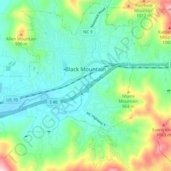
Name: Black Mountain topographic map, elevation, terrain.
Average elevation: 784 m
Minimum elevation: 681 m
Maximum elevation: 1,153 m
Other topographic maps
Click on a map to view its topography, its elevation and its terrain.
Asheville
United States > North Carolina > Buncombe County
Asheville, Buncombe County, North Carolina, United States
Average elevation: 727 m
Weaverville
United States > North Carolina > Buncombe County
Weaverville, Buncombe County, North Carolina, United States
Average elevation: 679 m
Pisgah National Forest
United States > North Carolina > Buncombe County
Pisgah National Forest, Buncombe County, North Carolina, United States
Average elevation: 752 m
Lake Powhatan
United States > North Carolina > Buncombe County
Lake Powhatan, Buncombe County, North Carolina, United States
Average elevation: 736 m
Rainbow Mountain
United States > North Carolina > Buncombe County > Montreat
Rainbow Mountain, Montreat, Buncombe County, North Carolina, 28757, United States
Average elevation: 871 m
Candler
United States > North Carolina > Buncombe County
Candler, Buncombe County, North Carolina, 28715, United States
Average elevation: 669 m
Haw Creek
United States > North Carolina > Buncombe County > Asheville
Haw Creek, Asheville, Buncombe County, North Carolina, 28805, United States
Average elevation: 669 m
Murphy Junction
United States > North Carolina > Buncombe County > Asheville
Murphy Junction, Asheville, Buncombe County, North Carolina, 28801, United States
Average elevation: 642 m
Arden
United States > North Carolina > Buncombe County > Asheville
Arden, Asheville, Buncombe County, North Carolina, 28704, United States
Average elevation: 691 m
Swannanoa
United States > North Carolina > Buncombe County
Swannanoa, Buncombe County, North Carolina, 28814, United States
Average elevation: 826 m
Alexander Knob
United States > North Carolina > Buncombe County
Alexander Knob, Buncombe County, North Carolina, 28709, United States
Average elevation: 1,145 m
Oteen
United States > North Carolina > Buncombe County > Asheville
Oteen, Asheville, Buncombe County, North Carolina, 28815, United States
Average elevation: 670 m
Beaverdam
United States > North Carolina > Buncombe County
Beaverdam, Buncombe County, North Carolina, United States
Average elevation: 778 m
Avery Creek
United States > North Carolina > Buncombe County
Avery Creek, Buncombe County, North Carolina, United States
Average elevation: 690 m
Grovemont
United States > North Carolina > Buncombe County > Swannanoa
Grovemont, Swannanoa, Buncombe County, North Carolina, 28778, United States
Average elevation: 764 m
Little Pisgah Camp Dam
United States > North Carolina > Buncombe County
Little Pisgah Camp Dam, Buncombe County, North Carolina, United States
Average elevation: 880 m
Flat Creek
United States > North Carolina > Buncombe County
Flat Creek, Buncombe County, North Carolina, 28787, United States
Average elevation: 688 m
Parkway Forest
United States > North Carolina > Buncombe County > Asheville
Parkway Forest, Asheville, Buncombe County, North Carolina, 28815, United States
Average elevation: 683 m
Fairview
United States > North Carolina > Buncombe County
Fairview, Buncombe County, North Carolina, 28730, United States
Average elevation: 742 m
Biltmore
United States > North Carolina > Buncombe County > Asheville
Biltmore, Asheville, Buncombe County, North Carolina, 28803, United States
Average elevation: 650 m
Albemarle
United States > North Carolina > Buncombe County > Asheville
Albemarle, Asheville, Buncombe County, North Carolina, 28802, United States
Average elevation: 718 m
Walker Falls
United States > North Carolina > Buncombe County
Walker Falls, Buncombe County, North Carolina, United States
Average elevation: 1,270 m
Busbee
United States > North Carolina > Buncombe County > Asheville
Busbee, Asheville, Buncombe County, North Carolina, 28803, United States
Average elevation: 725 m
Walkertown
United States > North Carolina > Buncombe County
Walkertown, Buncombe County, North Carolina, 28757, United States
Average elevation: 874 m
Beech
United States > North Carolina > Buncombe County
Beech, Buncombe County, North Carolina, United States
Average elevation: 892 m
Biltmore Forest
United States > North Carolina > Buncombe County
Biltmore Forest, Buncombe County, North Carolina, United States
Average elevation: 689 m
Highland Gate
United States > North Carolina > Buncombe County > Asheville
Highland Gate, Asheville, Buncombe County, North Carolina, 28802, United States
Average elevation: 707 m
Riceville
United States > North Carolina > Buncombe County
Riceville, Buncombe County, North Carolina, 28805, United States
Average elevation: 780 m
Woolsey
United States > North Carolina > Buncombe County > Asheville
Woolsey, Asheville, Buncombe County, North Carolina, 28804, United States
Average elevation: 680 m
Venable
United States > North Carolina > Buncombe County > Asheville
Venable, Asheville, Buncombe County, North Carolina, 28816, United States
Average elevation: 669 m
Canto
United States > North Carolina > Buncombe County
Canto, Buncombe County, North Carolina, 28853, United States
Average elevation: 698 m
Sandymush
United States > North Carolina > Buncombe County
Sandymush, Buncombe County, North Carolina, 28853, United States
Average elevation: 766 m
Woodfin
United States > North Carolina > Buncombe County
Woodfin, Buncombe County, North Carolina, United States
Average elevation: 673 m
Beaver Lake
United States > North Carolina > Buncombe County > Asheville > Grace
Beaver Lake, Grace, Asheville, Buncombe County, North Carolina, United States
Average elevation: 672 m
Malvern Hills
United States > North Carolina > Buncombe County > Asheville
Malvern Hills, Asheville, Buncombe County, North Carolina, 28806, United States
Average elevation: 645 m
Sayles Village
United States > North Carolina > Buncombe County > Asheville
Sayles Village, Asheville, Buncombe County, North Carolina, 28805, United States
Average elevation: 649 m
Ridgecrest
United States > North Carolina > Buncombe County > Ridgecrest
Ridgecrest, Buncombe County, North Carolina, 28770, United States
Average elevation: 875 m
Enka
United States > North Carolina > Buncombe County > Asheville
Enka, Asheville, Buncombe County, North Carolina, 28728, United States
Average elevation: 661 m
Owltown
United States > North Carolina > Buncombe County > Owltown
Owltown, Buncombe County, North Carolina, United States
Average elevation: 782 m
Enka Village
United States > North Carolina > Buncombe County > Asheville
Enka Village, Asheville, Buncombe County, North Carolina, 28728, United States
Average elevation: 670 m
Montreat
United States > North Carolina > Buncombe County
Montreat, Buncombe County, North Carolina, 28757, United States
Average elevation: 988 m
Boswell
United States > North Carolina > Buncombe County > Asheville > Boswell
Boswell, Asheville, Buncombe County, North Carolina, 28806, United States
Average elevation: 658 m
Leicester
United States > North Carolina > Buncombe County
Leicester, Buncombe County, North Carolina, 28748, United States
Average elevation: 648 m
Oak Forest
United States > North Carolina > Buncombe County > Asheville
Oak Forest, Asheville, Buncombe County, North Carolina, 28776, United States
Average elevation: 706 m
Linwood Park
United States > North Carolina > Buncombe County > Asheville
Linwood Park, Asheville, Buncombe County, North Carolina, 28803, United States
Average elevation: 654 m
South Slope
United States > North Carolina > Buncombe County > Asheville
South Slope, Asheville, Buncombe County, North Carolina, 28802, United States
Average elevation: 657 m
Sulphur Springs
United States > North Carolina > Buncombe County > Asheville
Sulphur Springs, Asheville, Buncombe County, North Carolina, 28806, United States
Average elevation: 661 m
Stony Fork
United States > North Carolina > Buncombe County
Stony Fork, Buncombe County, North Carolina, United States
Average elevation: 894 m
Barnardsville
United States > North Carolina > Buncombe County
Barnardsville, Buncombe County, North Carolina, 28709, United States
Average elevation: 765 m
Royal Pines
United States > North Carolina > Buncombe County > Asheville
Royal Pines, Asheville, Buncombe County, North Carolina, 28776, United States
Average elevation: 700 m