
Make a donation
Gear up for your next adventure:
As an Amazon Associate, this site earns from qualifying purchases at no extra cost to you.
Patna topographic map
Click on the map to display elevation.
Make a donation
Gear up for your next adventure:
As an Amazon Associate, this site earns from qualifying purchases at no extra cost to you.
Patna
Patna is on the southern bank of the river Ganges. The total area of Patna is 250 km2 (97 sq mi). Of this, the municipal area constitutes 109.218 km2 (42.169 sq mi). The suburban area covers 140.782 km2 (54.356 sq mi). It has an average elevation of 53 m (174 ft). A characteristic feature of the geography of Patna is its confluence of major rivers.
Make a donation
Gear up for your next adventure:
As an Amazon Associate, this site earns from qualifying purchases at no extra cost to you.
About this map
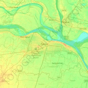
Name: Patna topographic map, elevation, terrain.
Location: Patna, Patna Rural, Patna, Bihar, 800001, India (25.44932 84.96353 25.76932 85.28353)
Average elevation: 51 m
Minimum elevation: 39 m
Maximum elevation: 65 m
Make a donation
Gear up for your next adventure:
As an Amazon Associate, this site earns from qualifying purchases at no extra cost to you.
Other topographic maps
Click on a map to view its topography, its elevation and its terrain.
Patna
India > Bihar > Patna Rural
Patna is on the southern bank of the river Ganges. The total area of Patna is 250 km2 (97 sq mi). The municipal area constitutes 109.218 km2 (42.169 sq mi). The suburban area covers 140.782 km2 (54.356 sq mi). It has an average elevation of 53 m (174 ft). A characteristic feature of the geography of Patna is…
Average elevation: 51 m