
Make a donation
Gear up for your next adventure:
As an Amazon Associate, this site earns from qualifying purchases at no extra cost to you.
Middle Cascades topographic map
Click on the map to display elevation.
Make a donation
Gear up for your next adventure:
As an Amazon Associate, this site earns from qualifying purchases at no extra cost to you.
About this map
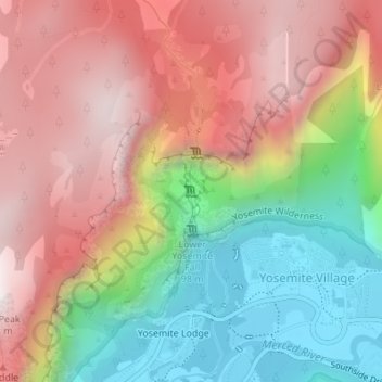
Name: Middle Cascades topographic map, elevation, terrain.
Average elevation: 1,783 m
Minimum elevation: 1,203 m
Maximum elevation: 2,325 m
Make a donation
Gear up for your next adventure:
As an Amazon Associate, this site earns from qualifying purchases at no extra cost to you.
Other topographic maps
Click on a map to view its topography, its elevation and its terrain.
Yosemite Valley
United States > California > Mariposa County > Yosemite Village
Average elevation: 2,016 m
Yosemite Valley
United States > California > Mariposa County > Yosemite Village
Average elevation: 2,012 m
Yosemite Valley
United States > California > Mariposa County > Yosemite Village
Average elevation: 2,016 m