
Make a donation
Gear up for your next adventure:
As an Amazon Associate, this site earns from qualifying purchases at no extra cost to you.
Kleinglattbach topographic map
Click on the map to display elevation.
Make a donation
Gear up for your next adventure:
As an Amazon Associate, this site earns from qualifying purchases at no extra cost to you.
Kleinglattbach
Kleinglattbach liegt gut zwei Kilometer nordöstlich der Kernstadt von Vaihingen an der Enz auf etwa 250 m Höhe am Glattbach. Benachbarte Ortschaften sind (von Nordwesten im Uhrzeigersinn) Ensingen, Horrheim, Sersheim, Vaihingen an der Enz und Illingen.
Make a donation
Gear up for your next adventure:
As an Amazon Associate, this site earns from qualifying purchases at no extra cost to you.
About this map
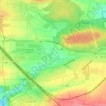
Name: Kleinglattbach topographic map, elevation, terrain.
Average elevation: 253 m
Minimum elevation: 212 m
Maximum elevation: 292 m
Make a donation
Gear up for your next adventure:
As an Amazon Associate, this site earns from qualifying purchases at no extra cost to you.