
Thank you for supporting this site ❤️
Make a donation
Make a donation
Gear up for your next adventure:
As an Amazon Associate, this site earns from qualifying purchases at no extra cost to you.
Ligonier topographic map
Click on the map to display elevation.
Thank you for supporting this site ❤️
Make a donation
Make a donation
Gear up for your next adventure:
As an Amazon Associate, this site earns from qualifying purchases at no extra cost to you.
About this map
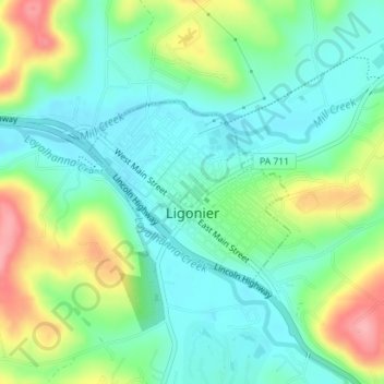
Name: Ligonier topographic map, elevation, terrain.
Location: Ligonier, Westmoreland County, Pennsylvania, United States (40.23811 -79.24717 40.25092 -79.22858)
Average elevation: 379 m
Minimum elevation: 343 m
Maximum elevation: 452 m
Thank you for supporting this site ❤️
Make a donation
Make a donation
Gear up for your next adventure:
As an Amazon Associate, this site earns from qualifying purchases at no extra cost to you.
Other topographic maps
Click on a map to view its topography, its elevation and its terrain.
Skunk Pond (Elevation 1100 feet)
United States > Pennsylvania > Westmoreland County > Murrysville
Average elevation: 323 m