
Stepaside topographic map
Interactive map
Click on the map to display elevation.
About this map
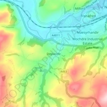
Name: Stepaside topographic map, elevation, terrain.
Location: Stepaside, Powys, Wales, SY16 4JQ, United Kingdom (52.47613 -3.37051 52.51613 -3.33051)
Average elevation: 196 m
Minimum elevation: 105 m
Maximum elevation: 355 m
Other topographic maps
Click on a map to view its topography, its elevation and its terrain.
Brecon Beacons National Park
United Kingdom > Wales > Powys
Brecon Beacons National Park, officially named Bannau Brycheiniog National Park (Welsh pronunciation), is a national park in Wales. It is named after the Brecon Beacons (Welsh: Bannau Brycheiniog), the mountain range at its centre. The national park includes the highest mountain in South Wales, Pen y Fan,…
Average elevation: 270 m